European space agency's satellite reveals image of mysterious Sahara bullseye
हिंदी में सुनें
Listen to this article in Hindi
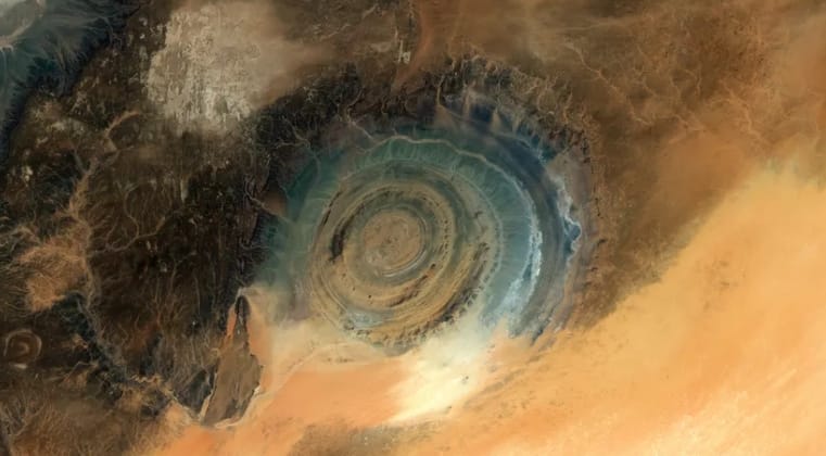
European Space Agency's satellite capture shows the Richat Structure in unprecedented clarity, revealing vivid rings across the Sahara and offering fresh insights into its ancient geological origins.
European Space Agency's satellite Copernicus Sentinel-2 has unveiled some new images of remote Saharan dome into a global scientific talking point. The Richat Structure, is a sprawling desert “eye” which appears sharper, brighter and more detailed than ever. This image offers new clues about its deep geological past.
What did satellites recently capture?
European satellite captured the Richat Structure with remarkable clarity recently. The formation sits within Mauritania’s arid Sahara Desert landscape today. Its concentric rings appear vividly across new multispectral orbital imagery.
The circular shape spans nearly fifty kilometres in total width. Scientists examined these images to understand its unusual symmetry clearly.
This structure once considered mysterious
Researchers long suspected an ancient meteor strike created the formation. Its perfect rings resembled typical impact craters seen on other planets. Field studies later found no shocked minerals beneath exposed sediment layers.
Absence of melted rock ruled out theories involving catastrophic collisions. Scientists therefore shifted explanations toward slower geological processes instead.
How did this circular landform actually form?
The structure began as a massive, uplifted dome millions of years. Molten rock slowly pushed upward beneath layers of ancient sedimentary stones. The erosion of the softer rock was performed by the wind acting over very long periods of time.
The rest that could not be lost were harder minerals that created the circular ridges as seen by space. The precipitation also formed bare areas in moving desert landscapes.
What do new images reveal about its geology?
False-colour composite brings to the fore mineral differences throughout the desert massive. It has layers of quartz that are separate as compared to darker volcanic remains along edges. The erosion features are visible in high resolution views, which were not visible during previous field works.
Astronauts often use the structure as an orbital navigation reference. These images illustrate Earth’s geological complexity viewed through satellite perspectives.
How will scientists investigate it further?
Future missions project entailed extended multiplex mapping of bare Saharan surfaces. Scientists anticipate a better chronology of the erosion steps in the layered rocks. Future samples will provide more hints regarding past evidence of tectonic uplift.
It is hoped that teams will determine the long-held geological questions by incorporating satellite observations in its use. The Richat Structure remains a key site for studying Earth’s evolution.